Study based on a massive data set spanning 19 countries in sub-Saharan Africa gives hope to improving water security for millions – through restorative management practices.
For many people in sub-Saharan Africa, reliable access to freshwater is not guaranteed year-round. As much as 90 per cent of agriculture depends on water from rainfall, and groundwater is a critical source of freshwater.
The replenishment of soil- and ground-water depends on whether and how water at the soil surface enters the soil, a process known as infiltration. One can think of soil as a sponge with pores. The larger these pores are and the more they are, the more water will infiltrate into the soil. This porosity depends in part on soil texture, the relative proportions of sand, silt and clay particles, but also on soil structure, how individual particles are assembled and arranged.
When infiltration is poor, water accumulates on the soil surface, resulting in surface runoff and low recharge of soil moisture and groundwater. This surface runoff, in turn, can lead to soil erosion and flooding. Maintaining and enhancing soil infiltration capacity is thus critical for improved water- and food security.
Filtering through decades of data
A new study led by researcher Aida Bargués Tobella at the Swedish University of Agricultural Sciences (SLU), sheds new light on the factors influencing soil infiltration capacity in sub-Saharan Africa. The study analyses data from over 3500 plots across 19 countries, spanning different climates, soil types and land uses, from grasslands to forests. The data set includes measurements of infiltration, vegetation cover, and various soil properties.
This giant database of soil and land health indicators of sub-Saharan African soils is hosted at the World Agroforestry Centre (ICRAF) in Nairobi, Kenya, where Aida Bargués Tobella spent two years processing and analysing the soil infiltration data.
Aida Bargués Tobella said, “ICRAF established the Land Degradation Surveillance Framework (LDSF) about 20 years ago in response to the need for indicator frameworks to measure and monitor soil and land health in a systematic, quantifiable, efficient and replicable way across landscapes. The LDSF database is one of the largest land health databases globally. It is one-of-a-kind, and it holds incredible potential.”
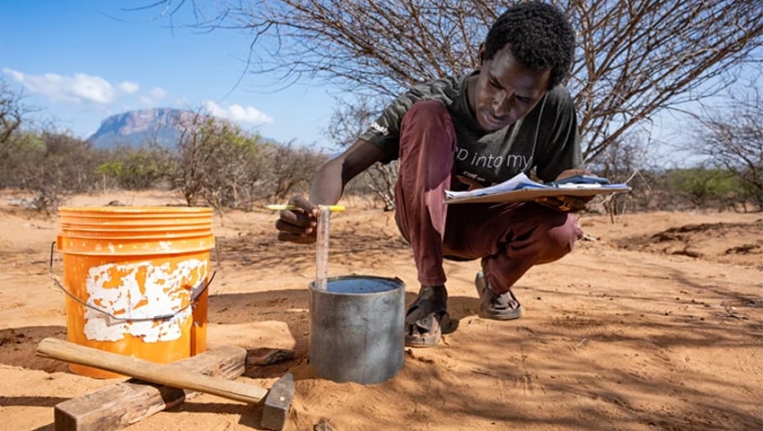
Of all the variables measured as part of the LDSF, soil infiltration is one of the most time-consuming measurements. A metal cylinder is inserted a few centimetres into the soil and filled with water. Over 2.5 hours, the cylinder is refilled at fixed time intervals, and the water level drop within the cylinder is measured with a ruler. The method is simple and manual, but effective and replicable virtually anywhere.
Aida Bargués Tobella said, “This method is simple and robust and allows for a higher sampling intensity. You just need a metal cylinder, water, and a ruler. Characterising the soil infiltration capacity over broad areas requires many field observations because infiltration varies greatly in space. It would be very difficult to obtain such many observations using more complex methods.”
Shows promising results for improving soil health and water security
The results show that soil infiltration capacity is affected by numerous factors. Soil texture is key, but there are also many other factors related to soil structure that are influenced by management, including soil organic carbon content, livestock stocking rates, or vegetation cover. For example, areas subjected to heavy grazing tended to have lower infiltration capacity due to animals trampling and compacting the soil, while areas with a higher cover of woody vegetation benefited from the enhanced porosity from litter and roots.
Co-author Douglas Sheil of Wageningen University said, “By making sure to maintain and rebuild the soil structure, the soil sponge, we can ensure there are sufficient pathways for water to infiltrate into the ground. The impact of these structure-altering processes on infiltration capacity brings hope for improving water security in the region.
“Millions in sub-Saharan Africa face daily hardship due to water scarcity, and this is expected to worsen. Our research offers hope by showing that people can manage their land to mitigate this crisis. Our research shows that practices, like promoting tree cover, can significantly improve water absorption and replenishment, ultimately boosting groundwater reserves and water security.”
Unique data can help predict effects of extreme weather
This unique data set of soil infiltration measurements and other indicators of soil and land health will be extremely valuable for improving hydrological models for applications in Africa. The data set expands databases of soil hydraulic properties, improving coverage for Africa and providing much-needed field data for underrepresented land uses and soils.
Under a future climate with more extreme weather events, such as heavy rainfall and drought, these data will become increasingly valuable in identifying which areas are more prone to flooding or drought, which is essential to strengthening existing Early Warning Systems.